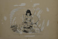
PEN AND INK DRAWINGS
Two original pen and ink drawings for The Littlest House by Margarite Davis, "The Berries lay in nest of pale blue" (page 105), and "Lydia handed them to her one by one" (page 67) along with the original page, on full illustration boards, 20" x 15" and 22" x 15", (JPR collection).
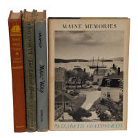
FOUR BOOKS BY ELIZABETH COATSWORTH
Coatsworth, Elizabeth; Maine Ways, 1st Edition, 1947, illustrated by Mildred Coughlin, The Macmillan Company, New York, original dust jacket, good condition; Maine Memories, The Stephen Greene Press, Brattleboro, Vermont, 1968, original dust jacket, good condition; South Shore Town, 1st Edition, 1948, The Macmillan Company, New York, signed in green ink on flyleaf, good condition, in pencil inside cover "acquired from Frances Foley, wife of Mason A. Foley Hingham, Mass...J.P. Richardson, 1974"; The Littlest House, illustrated by Margaret Davis, The Macmillan Company, New York, 1940, signed on inside in pencil and pen, tear at top right of inside page, stains; (JPR collection).
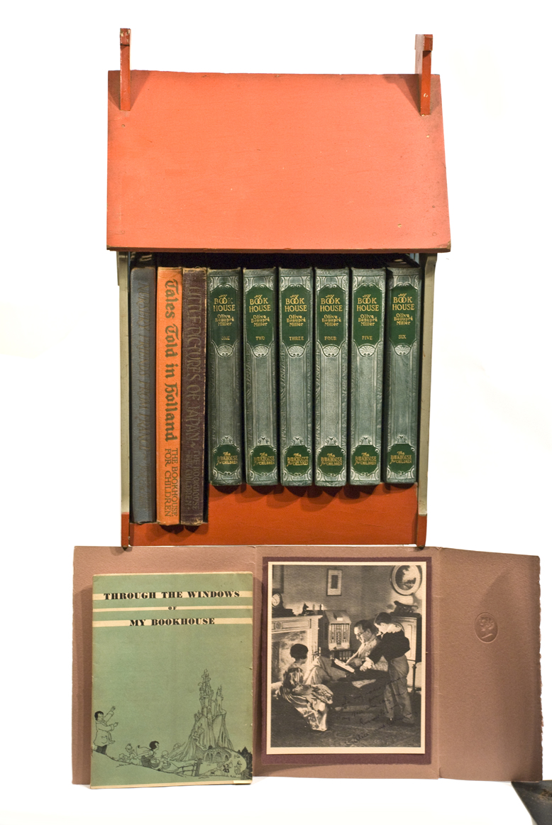
MY BOOKHOUSE BOOKS AND BOOKCASE
My Bookhouse by Olive Beanpre Miller, "The Bookhouse for Children", Vols. I-VI, 1925, 1928, Chicago, Tales Told in Holland, 1926, Little Pictures of Japan, 1925, all illustrated in color, Nursery Friends from France, songs and poems, contained in the original wood painted "Book House" from the Elizabeth Coatsworth Beston collection, (Note: Given to John P. Richardson by Elizabeth Coatsworth Beston and displayed in the window of the Hingham Bookshop), 22" h, 14" l, 12" d, (JPR collection).
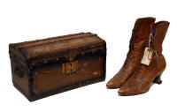
CHILD'S TRUNK AND LADIES BOOTS
Child's stagecoach trunk, wood slats, trimmed in black painted steel, covered in paint stripe canvas, brass lock plate, decorative blue and white cloth interior, removable tray with red taped open bottom, "I acquired this little chest from writer Elizabeth Coatsworth Beston..." (JPR 1973), 8" h, 14" l; and a pair of ladies brown leather high laced boots, "Acquired from Elizabeth Coatsworth Beston. When she and her famous author husband, Henry Beston, moved into the John Souther House on Ship St, Hingham Mass. these high shoes among other things were found in the attic, John P. Richardson...".
PAMPHLET/WOODCUTS BY HOSEA SPRAGUE
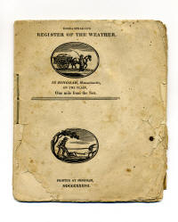
Sprague, Hosea, Register of the Weather and Meteorological Journal, very scarce pamphlet compiled by "Hingham's eccentric mid 19th c. printer, artist, historian, etc. Hosea Sprague (1779-1843)" (JPR); two oval shaped Hosea Sprague woodcuts on sewn paper, cover of a ploughman and a horse, wagon and driver, 32 pages, 1838, printed at Hingham, showing a table of the daily weather with the prevailing direction of the wind, temperature readings for sunrise, noon and sunset for 1836 and into April of 1837; also includes facts and philosophies of Sprague, (Note: a wonderful slice of Hingham history); (JPR collection).
PAMPHLET BY HOSEA SPRAGUE
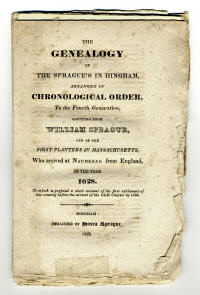
Sprague, Hosea, The Genealogy of the Sprague's in Hingham, paper pamphlet, 1828, published by Hosea Sprague, "Counting from William Sprague, one of the First Planters in Massachusetts in the Year 1628...", 60 pages, unsewn and some pages are uncut, minor foxing, a very interesting and rare source of history of the earliest Hingham Planter, also to include an additional pamphlet Ralph Sprague in Charlestown in 1628", "Printed for the Spragues and those friendly to them."; (JPR collection).
HOSEA SPRAGUE WOODCUT PRINT
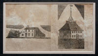
Sprague, Hosea; very rare 19th c. woodcut print on paper of two images, an early Hingham farm with barn and the Old Ship Church Meeting House, shows some slight tears and discoloration, central fold lines and small repairs, very clear images, framed and matted.
HOSEA SPRAGUE'S CHRONICLE
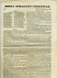
Sprague, Hosea, Hosea Sprague's Chronicle, No. 3, Wednesday February 1, 1843, four page periodical of historical facts and philosophies of Hosea Sprague of Hingham, "Travelers are plenty. I never travelled much; I never was seven leagues to the Westward of Boston Light House - nor eastward. The way I find out who has travelled is to go to Boston and buy half a bushel of old newspapers, and I can tell who has travelled all over the world.", (Note: these chronicles are "very scarce to rare" JPR), 8 1/2" x 14", double columned; sold by subscription from December 1842 to April 1843, approximately 75+ subscribers; along with a loose leaf notebook with JPR's notes, news clippings (Hingham Journal, 1939), many copies of Hosea Sprague's woodcuts, and xeroxed copies of the "Chronicle"; (JPR collection).
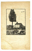
WOODCUT ENGRAVING BY HOSEA SPRAGUE
Sprague, Hosea, woodcut engraving of the 17th c. "Folsom" house with hay wagon, driver and four oxen in the front, and the saltbox style house behind a picket fence with outbuilding in the rear, 5 1/2" x 4" (sight), (paper - 10" x 6 1/4"), "He resided in the Folsom house. Woodcuts by Hosea Sprague are rare to extremely rare." (JPR); along with a woodcut engraving of the 17th c. Hingham division of shares of land among owners, attributed to Hosea Sprague, shows tears and repairs, laid on backing, 6 1/4" x 5 1/2"; (JPR collection).
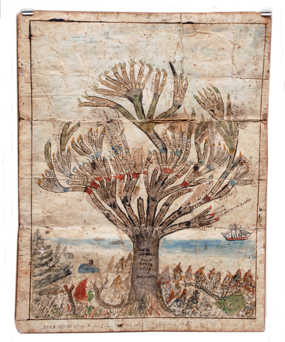
FAMILY TREE WATERCOLOR
Very rare watercolor family tree of descendants of "John Tower who left old Hingham, England and settled in Hingham Mass in 1637", depicting a large tree with names of descendants on the branches, in a landscape with a blue cape house and a ship at sail in Hingham harbor, linen backed, shows wrinkles, minor tears and fold lines, (Note: this piece is unsigned but attributed to Isaac Sprague, as he is known to have drawn several family trees for Hingham townspeople), 15 1/2" x 12".
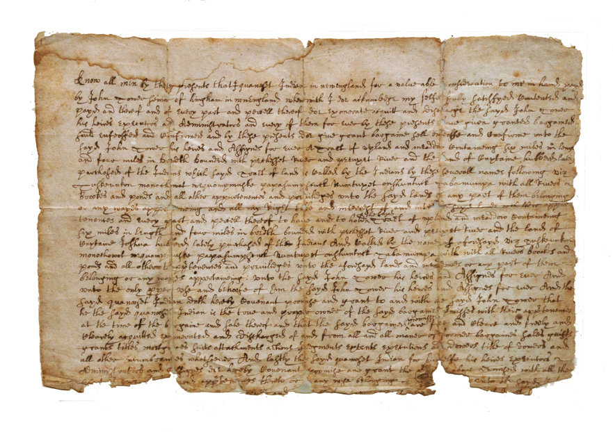
RARE 17TH C. DOCUMENT
An extremely rare 17th c. American document (partial), an "Indian Deed found in Daniel Cushing's papers as acquired with the Solomon Lincoln Papers..." John P. Richardson; "Know all men by these presents that (his mark), Quanosset Indian in New England for a valuable consideration to me in hand payed by John Tower farmer of hingham in new England wherwith (his mark) Joe acknowledge my self fully satisfied...", overall toning, fold lines, missing small parts at corners of fold lines, missing bottom part of document, appears to be backed on vellum, lightly taped on paper back, framed and glazed, (JPR collection).
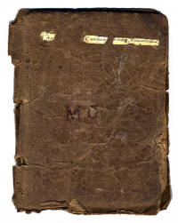
RARE 17TH C. BOOK AND DOCUMENT
One of the rarest books found in Hingham, "The Rare Jewel of Christian Contentment", handmade paper cover with stamped "M C" on the front, some pages missing, "as is", 7 1/2" h, 5 3/4" w; along with a handwritten history of the earliest parts of the Cushing family of Hingham, England, Matthew Cushing (1588-1660) married Nazareth Pitcher, they emigrated from Hingham, Norfolk, England to Hingham, Massachusetts, aboard the "Diligent" which arrived August 10, 1638; "1645 pamphlet found in Matthew Cushing House at Pear Tree Hill, Main St, before house was razed in 1887" (JPR collection).
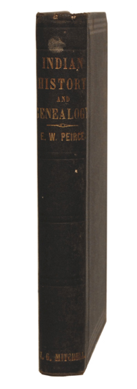
INDIAN HISTORY... BY EBENEZER PEIRCE
Peirce, Ebenezer; Indian History, Biography and Geneology: Pertaining to the Good Sachem Massasoit of the Wampanoag Tribe, and his Descendants with an Appenic. North Attleboro, MA: 1878. 19.5 cm. illustrated. Embossed and gilt cloth. Some wear to cloth. Very good. Howes P178; (JPR collection).
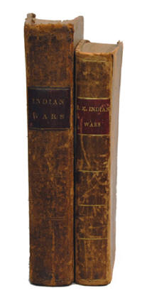
TWO BOOKS FROM I. SPRAGUE'S LIBRARY
Hubbard, William, Narrative of the Indian Wars in New England..., printed at Worcester, by Daniel Greenleaf for Joseph Wilder, 1801, age toning, two pages with sewn repairs (185 and 187), 410 pages: Drake, Samuel G., History of Philips War..., Boston, J.A. Frost 1827; both from the library of Isaac Sprague, one signed and dated "1842"; (JPR collection).
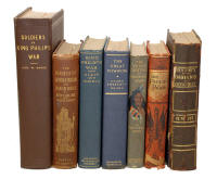
BOOKS ON KING PHILIP'S WAR
Seven books concerning King Philip's War: Trumbull, Henry, History of the Indian Wars, Phillips and Sampson, Boston, 1846, pull-out color plate, some foxing throughout, good condition, Field 1570; Sears, Clara Endicott, The Great Powwow, Houghton Mifflin Co., Boston, 1934, no dust jacket, small paint mark on back, very good condition; Caverly, Robert B., The Heroism of Hannah Duston and Indian Wars of New England, B.B. Russel & Co. Publishers, Boston, 1874, some foxing on title page, minor wear on top and bottom of spine, overall good condition; Smith, Mary P. Wells, The Young Puritans in King Philip's War, Little, Brown, and Co., 1898, minor wear, overall good condition; Markham, Richard, King Philip's War, Dodd, Mead & Co., New York, 1883, title page removed, minor wear on top and bottom of spine, overall good condition; Ellis, George W. & Morris, John E., King Philip's War, The Grafton Press, New York, 1906, very good condition; Bodge, George Madison, Soldiers in King Philip's War, The Rockwell and Church Press, Boston, 1906, fold-out map, very good condition; (JPR collection).
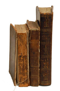
BOOKS BY SAMUEL DRAKE
Drake, Samuel G., Three Volumes: The History of Philip's War, Exeter, NH, 1829, 2nd Ed., missing plates, loose covers; Indian Biography...Two Hundred Indian Chiefs..., Boston, 1832, loose cover, (signed in pencil at top of title page "Isaac Sprague"; and The Book of the Indians of North America,...lives of about five hundred Chiefs..., Boston, 1833, some foxing; (JPR collection).
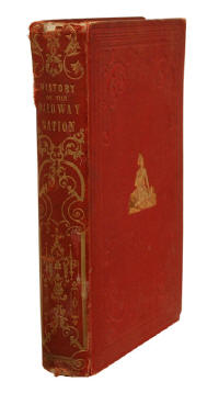
TRADITIONAL HISTORY OF OJIBWAY NATION
Copway, G. (Kah-Ge-Ga-Gah-Bowh, Chief of the Ojibway Nation); The Traditional History of the Ojibway Nation. Boston: 1851. Illustrated. 19.5 cm. Embossed and gilt pictorial binding. Wear to binding. Some foxing. Good. Field 365. Howes C772; (JPR collection).
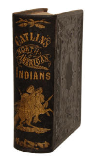
MANNERS, CUSTOMS...NORTH AMERICAN INDIANS
Catlin, George; Letters and Notes on the Manners, Customs, and Condition of the North American Indians... Philadelphia:1860. Two volumes in one. One hundred and fifty illustrations, many of which are cololred. 23 cm. Embossed and gilt pictorial cloth. Marbled edges. Some stains internally. Very good. Wagner-Camp 84, 20; (JPR collection).
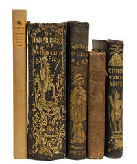
BOOKS CONCERNING INDIANS
Five miscellaneous books concerning Indians: Goodrich, Samuel, The Manners, Customs and Antiquities of the Indians of North and South America, Rand and Mann, Boston, 1849, small piece missing on front side of spine, overall good condition; Brownell, Charles DeWolf, The Indian Races of North and South America, Horace Wentworth, Boston, 1853, signed, many colored plates, overall good condition; DeForest, John W., History of the Indians of Connecticut, W.M. Jas. Hamersley, Hartford, 1851, pull-out map, back cover almost removed from spine, spine has split in center, see Field 414; McIntosh, John, The Origin of the North American Indians, Nafis & Cornish, New York, 1844, some water damage; Stratton, R.B., Captivity of the Oatman Girls Among the Apache and Mohave Indians, Grabhorn Press, San Francisco, 1935, Limited to 550 copies; (JPR collection).
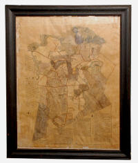
MAP OF HINGHAM, MASSACHUSETTS
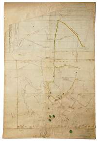
Rare and unique hand-drawn map of Hingham, Massachusetts on three separate sheets glued together and backed on woven linen canvas, initialed "R.H. Jr. No. 23, Hingham" on lower left corner, pen and ink and watercolor showing streets, buildings as schools and churches, hills, the harbor with islands as "Button and Ragged" island, and World's End, "Recently discovered in my attic, 1830 primitive Hingham map by "RH" - Reuben Hersey Jr....John Richardson, 2010", written on lower right "Frances H. Lincoln, acquired from Henrietta Hilles 1969 John P. Richardson, 99 Fort Hill, Hingham.", 31 1/2" x 22".
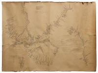
MAP OF HINGHAM, MASSACHUSETTS
Rare hand-drawn map of Hingham, Massachusetts on thin brown paper applied to a white backing, pen and ink and watercolor, showing streets, house lots with names of owners, ponds, hills, islands, and coves, "1840's watercolor based upon the Reuben Hersey/Jedediah Lincoln 1830 map...Note the arrows pointing to William Hersey's 1636 House Lot Grant as well as the location of Hersey Farm..." (JPR), in an early glazed oak frame in black paint, 26" x 19 1/2" (sight).
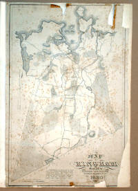
MAP OF HINGHAM, MASSACHUSETTS
Printed "Map of Hingham surveyed by Jedediah Lincoln and Reuben Hersey Jr. in 1830", showing ponds, forests, harbor with islands, streets and houses, map is missing two corners and small upper parts, tape stains and foxing, some tears and wrinkles, in pencil on back "Found in tattered condition on upper story of the barn (on wall) at the William Hersey - Gay House 262 South St, Hingham, J.P. Richardson 1958.", 23" x 28".
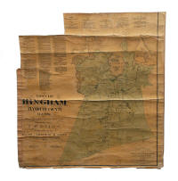
TWO MAPS OF HINGHAM, MASSACHUSETTS
Printed "Town of Hingham, Plymouth County Maps", F.W. Beers, 1873 N.Y., lacquered, with folds, missing top and side section, overall town plan is intact, 100 rods to the inch, 29" x 28"; and a hand-drawn map by C.H. Marbles of the original 1792 plan of Hingham, identifying land owners, 22" x 30"; (JPR collection).
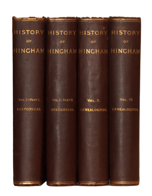
HISTORY OF HINGHAM
History of the Town of Hingham Massachusetts, John Wilson & Son, Cambridge, 1893, Vol. I-III, (Vol. I is two vols. - four vols. total), University Press, Historical & Genealogical, illustrated with maps and photographs, (JPR collection).
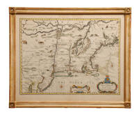
MAP OF NEW ENGLAND AND NEW YORK
"A Map of New England and New York. Sold by Thomas Bassett in Fleet Street and Richard Chiswell in St. Paul's Churchyard" by John Speed, 1676. Hand colored copper plate engraving, fine and well colored impression, Tooley: "America" #2; McCorkle: "New England" 676.6. Provenance: The Old Print Shop, New York City (labeled on back). Very good condition, gold leaf frame, UV glass, acid-free backing by Fred Roberts of Wilton, CT,15" x 19 3/4" (sight), 19 1/2" x 23 3/4" (framed).
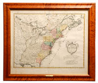
CHART OF NORTH AMERICA
An 18th c. map of the Eastern Seaboard of North America, "Charte uber die XIII vereinigte Staaten von Nord America" 1784, by Homann's Heirs, also titled at the top in French: "Les XIII Etats unis de l'Amerique Septentrionale". Maine through Georgia in full color. Maine is shown as a "Province" of Massachusetts Bay. New Hampshire encompasses all of Vermont. Depicts the Mississipi River as the western boundary of the United States, in accordance with the treaty with Great Britain ending the American Revolution. Shows western areas as inhabited by Indian tribes only. A fictitious lake is shown to the west of Pennsylvania and Maryland. Florida is a Spanish possession. Provenance: Frank Oppel, Stamford, CT. Good condition except for some very light staining at top fold, tiger maple frame, UV glass, acid-free backing by Fred Roberts of Wilton, CT, 20 1/2" x 24 7/8" (sight), 25 1/4" x 29 1/8" (framed).
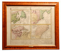
FOUR-SECTION MAP OF NORTH AMERICA
An 18th c. map of the Eastern Seaboard of North America, "Dominia Anglorum in America Septentrionali Specialibus Mappis Londini primum a Mollio edita nune recul'a ab Hommanianus Hered". This map, printed in 1763, divides the North American eastern seaboard into four separate maps as follows: "A. New Foundland, ed. Terra Nova S. Laurenth Bay, die Fiseh Bank, Acadia, New Scotland" showing Newfoundland, Nova Scotia, and most of Maine as part of New Brunswick; "B. New Engelland, New York, New Yersey and Pensilvania" showing Delaware as part of Pennsylvania; "C. Virginia and Maryland" including the Chesapeake Bay and the Potomac, Rappahanock and James Rivers; "D. Carolina and Florida". See Van Ermen in "The United States in Old Maps and Prints" #40. This map appears to have its full original hand coloring. Provenance: Frank Oppel, Stamford, CT. Good condition except for two small areas of missing paper outside border in the lower portion, tiger maple frame, UV glass, acid-free backing by Fred Roberts of Wilton, CT, 21" x 25" (sight), 25 1/4" x 29 1/2" (framed).

18TH C. MAP OF LOUISIANA
An 18th c. map showing the Eastern Seaboard of North America and the Mississippi Delta Basin, "Amplissimae Regionis Mississipi seu Provinciae Ludoviciannae" by Johann Baptiste Homann c. 1730 (-1753). Fully hand colored, wonderfully detailed and visually impressive map. With charming representations of the American wood Bison, Father Antoine Hennepin and Niagara Falls (who provided the first description of Niagara Falls, pictured under the title inscription of this map. See Van Ermen in "The United States in Old Maps and Prints" #24. Shows the English Colonies from Maine to the Carolinas, Spanish Florida, French Louisiana, Southern Canada and Northeastern Mexico. Shows a very large part of what would, seven decades later, become the "Louisiana Purchase". Modern hand coloring. Provenance: William R. Talbot Antique Maps, Santa Fe, NM. Very good condition, tiger maple frame, UV glass, acid-free backing by Fred Roberts of Wilton, CT, 19 5/8" x 23 1/2" (sight), 24 1/2" x 28" (framed).
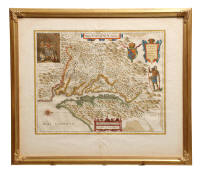
17TH C. MAP OF VIRGINIA
A 17th c. map of Virginia and the Chesapeake Bay, "Nova Virginiae Tabula" by Jodocus Hondius, Jr. and Willem J. Blaeu, Amsterdam, 1630-1638. Hand colored copper plate engraving. This map was the first derivative of the very important John Smith map of Virginia of 1612. Hondius first issued the map in 1618. Blaeu purchased the copper plate of this map in 1629-1630 and changed the imprint to "ex officina Guiljelmi Blaaeuw". French text and "9 Amerique 1" on the reverse. Modern hand coloring. It is #193 in the "Mapping of North America" by Philip Burden. Provenance: The Old Print Shop, New York City (labeled on back). Very good condition except for repaired splitting along lower centerfold, gold leaf frame, UV glass, acid-free backing by Fred Roberts of Wilton, CT, 15" x 19 3/8" (sight), 26" x 22" (framed).
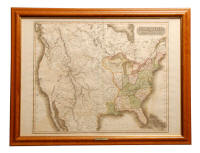
MAP OF U.S. AND ADDITIONS
A 19th c. map of the "United States and Additions, 1820", engraved for "Thomson's New General Atlas" 1820. Depicts the new American Nation from New England to Georgia and west to Indiana and south to Louisiana. Shows Illinois and Michigan as Territories, as well as the "Northwest Territory" and the "Missouri Territory". Depicts most of Canada from the Atlantic to the Pacific, and the American Far West and Southwest as part of Mexico. States are in full color. Appears to have original hand coloring. A great map showing the first development of the United States from the Atlantic to the Mississippi River, as well as the location of Indian tribes. Provenance: Frank Oppel, Stamford, CT. Tiger maple frame, UV glass, acid-backing by Fred Roberts, Wilton, CT, 21" x 27 7/8" (sight), 24 1/2" x 31 1/2" (framed).
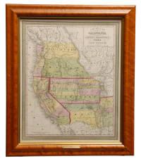
OREGON TERRITORY MAP
A 19th c. map of the "Oregon Territory" 1833. Illman & Pillow, New York. Depicts Oregon Territory extending to latitude 54 degrees 40 minutes North (famous for the American rallying cry "54-40 or Fight!") and including all of Vancouver Island, Queen Charlotte Island and a large part of British Columbia. Appears to have original hand coloring. Wonderful early map of Oregon, Washington and Idaho after Lewis and Clark but before any development. Columbia River depicted as "Columbia or Oregon River". Locates Indian tribes. Provenance: Frank Oppel, Stamford, CT. Tiger maple frame, UV glass, acid-free backing by Fred Roberts of Wilton, CT, 12" x 14 3/4" (sight), 15 3/4" x 18 1/4" (framed).
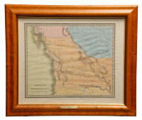
WESTERN TERRITORIES MAP
A 19th c. map of the Western Territories and "A New Map of the State of California, the Territories of Oregon, Washington, Utah & New Mexico" 1853. By Thomas Cowperthwait & Co., Philadelphia. Full color. Utah Territory encompasses most of present-day Colorado, all of Utah and most of Nevada. New Mexico Territory encompasses New Mexico and most of present-day Arizona, the southerly boundary being the Salt River (pre-Gadsden Purchase). Tucson is shown as part of Mexico. Oregon and Washington Territories include all of present-day Idaho. Western Montana is visible. Appears to have original hand coloring. The first division of the American Southwest and following its annexation in the Mexican War of 1848. The American Northwest is shown after the settlement between the U.S. and Great Britain at the 49th Parallel. Tiger maple frame, UV glass, acid-free backing by Fred Roberts of Wilton, CT, 16 1/4" x 13 1/8" (sight), 20" x 16 7/8" (framed).
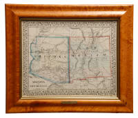
MAP OF ARIZONA AND NEW MEXICO
A 19th c. map of "Arizona and New Mexico" 1867. By S. Augustus Mitchell, Philadelphia. Full color. Depicts these as Territories some 45 years before admission to the Union. The southerly boundary is "According to the Gadsden Treaty of 1854". In Arizona, Tucson and Prescott are shown, but there is no Phoenix yet. Location of Army forts, including Fort Yuma, Fort Whipple and Fort Defiance are shown, as well as location of Indian tribes. In New Mexico, Santa Fe and Albuquerque are prominent. Appears to have original hand coloring. Tiger maple frame, UV glass, acid-free backing by Fred Roberts of Wilton, CT, 11 3/4" x 14 1/2" (sight), 16 1/2" x 19 1/4" (framed).
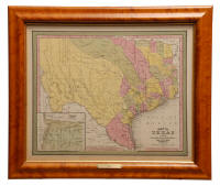
TEXAS MAP
A 19th c. "Map of Texas from the Most Recent Authorities" 1847. By C.S. Williams, Philadelphia. Full color. Inset of Texas panhandle. A very early map of Texas, printed just two years after statehood. The eastern counties are delineated but the western half of the State (Bexar County) is virtually undeveloped. Tiger maple frame, UV glass, acid-free backing by Fred Roberts of Wilton, CT, 13 1/4" x 15 7/8" (sight), 16 3/4" x 19 3/8" (framed).
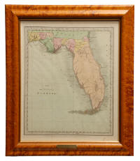
TERRITORY OF FLORIDA MAP
A 19th c. "Map of the Territory of Florida" 1834. By Illman & Pillow, New York. Depicts a completely undeveloped State except for the Florida panhandle and the very northern two counties. Full color. Locates rivers and lakes, including "Lake Mayacoo" (Lake Okeechobee). A very wonderful map of Florida eleven years before it was admitted to the Union. Appears to have original hand coloring. Tiger maple frame, UV glass, acid-free backing by Fred Roberts of Wilton, CT, 11 3/8" x 14 1/4" (sight), 15" x 17 7/8" (framed).